
Make a donation
Gear up for your next adventure:
As an Amazon Associate, this site earns from qualifying purchases at no extra cost to you.
Hohenpölz topographic map
Click on the map to display elevation.
Make a donation
Gear up for your next adventure:
As an Amazon Associate, this site earns from qualifying purchases at no extra cost to you.
Hohenpölz
Der 30 Meter hohe, massiv wirkende Glockenturm der Kirche mit seiner Zwiebelhaube ist fast von überall auf den Höhen des Fränkischen Juras als Orientierung zu sehen. Hohenpölz liegt am nördlichen Ende des Markts Heiligenstadt. Nachbarorte sind (im Uhrzeigersinn) Laibarös, Huppendorf, Voitmannsdorf, Brunn, Oberleinleiter und die Heroldsmühle.
Make a donation
Gear up for your next adventure:
As an Amazon Associate, this site earns from qualifying purchases at no extra cost to you.
About this map
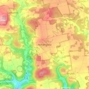
Name: Hohenpölz topographic map, elevation, terrain.
Average elevation: 1,565 ft
Minimum elevation: 1,289 ft
Maximum elevation: 1,778 ft
Make a donation
Gear up for your next adventure:
As an Amazon Associate, this site earns from qualifying purchases at no extra cost to you.
Other topographic maps
Click on a map to view its topography, its elevation and its terrain.
91332
Deutschland > Bayern > Landkreis Bamberg > Heiligenstadt i. OFr. > Burggrub
Average elevation: 1,555 ft