
Make a donation
Gear up for your next adventure:
As an Amazon Associate, this site earns from qualifying purchases at no extra cost to you.
Broumov topographic map
Click on the map to display elevation.
Make a donation
Gear up for your next adventure:
As an Amazon Associate, this site earns from qualifying purchases at no extra cost to you.
Broumov
Broumov is located about 22 km (14 mi) northeast of Náchod and 19 km (12 mi) south of the Polish city of Wałbrzych. The municipal territory shortly borders Poland in the north. It lies in the Broumov Highlands. The highest point is the hill Bobří vrch with an altitude of 740 m (2,430 ft). The town is situated on the Stěnava River. The territory lies entirely in the Broumovsko Protected Landscape Area.
Make a donation
Gear up for your next adventure:
As an Amazon Associate, this site earns from qualifying purchases at no extra cost to you.
About this map
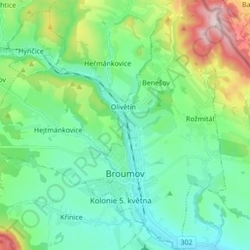
Name: Broumov topographic map, elevation, terrain.
Average elevation: 1,506 ft
Minimum elevation: 1,191 ft
Maximum elevation: 2,457 ft
Make a donation
Gear up for your next adventure:
As an Amazon Associate, this site earns from qualifying purchases at no extra cost to you.
Other topographic maps
Click on a map to view its topography, its elevation and its terrain.