
Make a donation
Gear up for your next adventure:
As an Amazon Associate, this site earns from qualifying purchases at no extra cost to you.
Baduraliya topographic map
Click on the map to display elevation.
Make a donation
Gear up for your next adventure:
As an Amazon Associate, this site earns from qualifying purchases at no extra cost to you.
Baduraliya
Baduraliya (Sinhala: බදුරලිය) is a town in the Kalutara District in Sri Lanka. It is approximately 82 km (51 mi) from Colombo and 58 km (36 mi) from Rathnapura. Baduraliya was named after a rally against taxes. "Badu" in Sinhala means taxes and “raliya” means a rally. Baduraliya is surrounded by tea plantations and rubber estates, and it is at an altitude of 27 m (89 ft) above sea level.
Make a donation
Gear up for your next adventure:
As an Amazon Associate, this site earns from qualifying purchases at no extra cost to you.
About this map
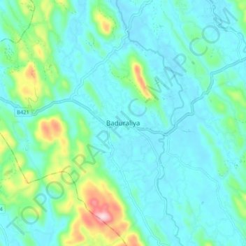
Name: Baduraliya topographic map, elevation, terrain.
Average elevation: 220 ft
Minimum elevation: 26 ft
Maximum elevation: 1,070 ft
Make a donation
Gear up for your next adventure:
As an Amazon Associate, this site earns from qualifying purchases at no extra cost to you.