
Make a donation
Gear up for your next adventure:
As an Amazon Associate, this site earns from qualifying purchases at no extra cost to you.
Modasa topographic map
Click on the map to display elevation.
Make a donation
Gear up for your next adventure:
As an Amazon Associate, this site earns from qualifying purchases at no extra cost to you.
Modasa
Modasa is located at 23°28′N 73°18′E / 23.47°N 73.3°E / 23.47; 73.3. It has an average elevation of 197 metres (646 feet). Most of the water for Modasa comes from the Mazum river, on which, about 5 kilometers from Modasa, the Mazum reservoir is situated.
Make a donation
Gear up for your next adventure:
As an Amazon Associate, this site earns from qualifying purchases at no extra cost to you.
About this map
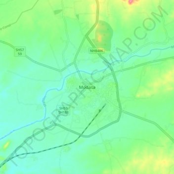
Name: Modasa topographic map, elevation, terrain.
Location: Modasa, Modasa Taluka, Aravalli, Gujarat, 383315, India (23.42342 73.25906 23.50342 73.33906)
Average elevation: 489 ft
Minimum elevation: 410 ft
Maximum elevation: 692 ft
Make a donation
Gear up for your next adventure:
As an Amazon Associate, this site earns from qualifying purchases at no extra cost to you.