Geolocate

Fargo topographic map

Click on the map to display elevation.

About this map

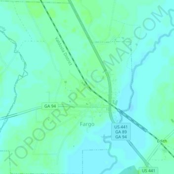
Name: Fargo topographic map, elevation, terrain.

Location: Fargo, Clinch County, Georgia, United States (30.67294 -82.58907 30.70378 -82.55697)

Average elevation: 112 ft

Minimum elevation: 98 ft

Maximum elevation: 125 ft

Clinch County trails, hiking, mountain biking, running and outdoor activities

Other topographic maps

Click on a map to view its topography, its elevation and its terrain.

Du Pont

United States > Georgia > Clinch County

Average elevation: 180 ft

Argyle

United States > Georgia > Clinch County

Average elevation: 161 ft

Gear up for your next adventure:

🧦Merino Wool Socks - Moisture-wicking, blister-preventing socks for long treks
🛏️Cold Weather Sleeping Bag - Warm sleeping bag for cold conditions
🧭Compass with Lanyard - Easy‑carry compass for navigation
📌Outdoor GPS Map App - Apps and devices for digital topographic navigation
🧺Microfiber Travel Towels - Compact and fast-drying towels for trail use

As an Amazon Associate, this site earns from qualifying purchases at no extra cost to you.