Geolocate

Athirappilly topographic map

Click on the map to display elevation.

About this map

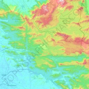
Name: Athirappilly topographic map, elevation, terrain.

Location: Athirappilly, Chalakkudy, Thrissur District, Kerala, India (10.25126 76.44857 10.38597 76.90142)

Average elevation: 1,332 ft

Minimum elevation: 0 ft

Maximum elevation: 5,262 ft

Other topographic maps

Click on a map to view its topography, its elevation and its terrain.

Mala

India > Kerala > Chalakkudy

Average elevation: 26 ft

Vallakkunnu

India > Kerala > Chalakkudy

Average elevation: 33 ft

Koratty

India > Kerala > Chalakkudy

Average elevation: 46 ft

annamanada

India > Kerala > Chalakkudy

Average elevation: 23 ft

Valiyaparambu

India > Kerala > Chalakkudy

Average elevation: 26 ft

V.R Puram

India > Kerala > Chalakkudy

Average elevation: 43 ft

Nandipulam

India > Kerala > Chalakkudy

Average elevation: 52 ft

Pulikkanny

India > Kerala > Chalakkudy

Average elevation: 118 ft

Chalakudy

India > Kerala > Chalakkudy

Average elevation: 49 ft

Lower Sholayar Dam

India > Kerala > Chalakkudy

Average elevation: 2,536 ft

Chalakudy

India > Kerala > Chalakkudy

Average elevation: 49 ft

Chalakudy

India > Kerala > Chalakkudy

Average elevation: 49 ft

Gear up for your next adventure:

🥾Hiking Shoes - Durable and comfortable shoes for trail hiking
📷Action Cameras - Rugged cameras to document your journeys across rugged terrain
🛰️Satellite Messengers - Emergency SOS and two-way messaging for off-grid adventures
📌Outdoor GPS Map App - Apps and devices for digital topographic navigation
🔦LED Headlamp - Bright and durable LED headlamp for night navigation

As an Amazon Associate, this site earns from qualifying purchases at no extra cost to you.