
Make a donation
Gear up for your next adventure:
As an Amazon Associate, this site earns from qualifying purchases at no extra cost to you.
Alpen topographic map
Click on the map to display elevation.
Make a donation
Gear up for your next adventure:
As an Amazon Associate, this site earns from qualifying purchases at no extra cost to you.
About this map
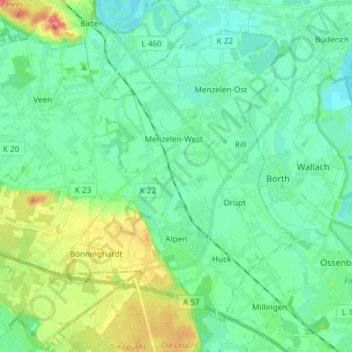
Name: Alpen topographic map, elevation, terrain.
Location: Alpen, Kreis Wesel, Nordrhein-Westfalen, 46519, Deutschland (51.55482 6.41375 51.63179 6.56314)
Average elevation: 92 ft
Minimum elevation: 39 ft
Maximum elevation: 246 ft
Make a donation
Gear up for your next adventure:
As an Amazon Associate, this site earns from qualifying purchases at no extra cost to you.
Other topographic maps
Click on a map to view its topography, its elevation and its terrain.
Krudenburg
Deutschland > Nordrhein-Westfalen > Kreis Wesel
Maximilianpark | Schulweg-Steg | Schleuse Werries | Lippeschleuse Heessen | Kurpark Hamm | Wasserübergabe Hamm | Schleuse Hamm | Klostermühle Pohl | Wassertürme am Hellweg | Bahnhof Hamm | Stadthafen Hamm | Zeche Sachsen heute Öko-Zentrum NRW | Siedlung Vogelsang | Zeche Radbod | Gedenkstätte Zeche Radbod…
Average elevation: 108 ft
Make a donation
Gear up for your next adventure:
As an Amazon Associate, this site earns from qualifying purchases at no extra cost to you.