Geolocate

Bantud topographic map

Click on the map to display elevation.

About this map

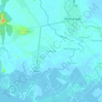
Name: Bantud topographic map, elevation, terrain.

Location: Bantud, Dumangas, Iloilo, Western Visayas, 5006, Philippines (10.78890 122.68375 10.82890 122.72375)

Average elevation: 13 ft

Minimum elevation: -7 ft

Maximum elevation: 135 ft

Gear up for your next adventure:

📦Gear Storage Bags - Organize and protect outdoor equipment
🎒Trail Energy Bars - High‑calorie bars for hiking energy
GPS Sports Watch - GPS watch for running, hiking and training
Backpacking Tents - Weight-optimized shelters for multi-day topographic surveys
🏫Relief Map Kits - Hands-on tools for teaching landforms and elevation

As an Amazon Associate, this site earns from qualifying purchases at no extra cost to you.