Geolocate

Tortuga topographic map

Click on the map to display elevation.

About this map

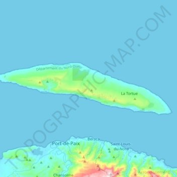
Name: Tortuga topographic map, elevation, terrain.

Location: Tortuga, Arrondissement Port-de-Paix, Nord-Ouest Department, Haiti (19.99243 -72.97090 20.08963 -72.62000)

Average elevation: 157 ft

Minimum elevation: 0 ft

Maximum elevation: 2,979 ft

Other topographic maps

Click on a map to view its topography, its elevation and its terrain.

La Tendrie

Haiti > Nord-Ouest Department > Port-de-Paix

Average elevation: 33 ft

Gear up for your next adventure:

🪶Thermal Camp Blanket - Extra warmth for cold nights
🛠️Backpacking Tool Kit - Essential toolkit for outdoor repairs
🛌Ultralight Sleeping Bags - Compact down bags for cold nights in the wilderness
📻Weather Alert Radios - Stay informed of storm risks while off-the-grid
🪵Folding Camp Saw - Compact saw for wood and campsite work

As an Amazon Associate, this site earns from qualifying purchases at no extra cost to you.