
Thank you for supporting this site ❤️
Make a donation
Make a donation
Gear up for your next adventure:
As an Amazon Associate, this site earns from qualifying purchases at no extra cost to you.
Gasen topographic map
Click on the map to display elevation.
Thank you for supporting this site ❤️
Make a donation
Make a donation
Gear up for your next adventure:
As an Amazon Associate, this site earns from qualifying purchases at no extra cost to you.
About this map
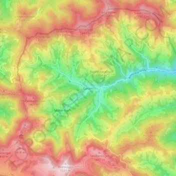
Name: Gasen topographic map, elevation, terrain.
Location: Gasen, Bezirk Weiz, Stiermarken, 8616, Oostenrijk (47.35334 15.53131 47.41338 15.62926)
Average elevation: 3,720 ft
Minimum elevation: 2,405 ft
Maximum elevation: 4,993 ft
Thank you for supporting this site ❤️
Make a donation
Make a donation
Gear up for your next adventure:
As an Amazon Associate, this site earns from qualifying purchases at no extra cost to you.
Other topographic maps
Click on a map to view its topography, its elevation and its terrain.
Wildkogel
Oostenrijk > Stiermarken > Bezirk Weiz > Fladnitz an der Teichalm
Average elevation: 3,461 ft