
Make a donation
Gear up for your next adventure:
As an Amazon Associate, this site earns from qualifying purchases at no extra cost to you.
Koohrang topographic map
Click on the map to display elevation.
Make a donation
Gear up for your next adventure:
As an Amazon Associate, this site earns from qualifying purchases at no extra cost to you.
About this map
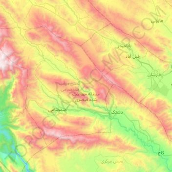
Name: Koohrang topographic map, elevation, terrain.
Average elevation: 8,238 ft
Minimum elevation: 4,439 ft
Maximum elevation: 13,517 ft
Make a donation
Gear up for your next adventure:
As an Amazon Associate, this site earns from qualifying purchases at no extra cost to you.
Other topographic maps
Click on a map to view its topography, its elevation and its terrain.
Kuhrang County
Iran > Chaharmahal and Bakhtiyari Province > Kuhrang County
Average elevation: 7,474 ft
Zard Kuh
Iran > Chaharmahal and Bakhtiyari Province > Kuhrang County > شهریاری
Average elevation: 12,493 ft
Chelgerd
Iran > Chaharmahal and Bakhtiyari Province > Kuhrang County > Chelgerd
Average elevation: 8,127 ft