Geolocate

Membakut topographic map

Click on the map to display elevation.

About this map

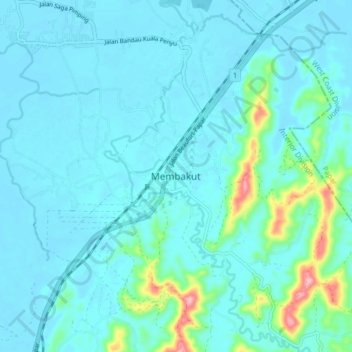
Name: Membakut topographic map, elevation, terrain.

Location: Membakut, Beaufort, Interior Division, Sabah, Malaysia (5.43529 115.76347 5.51529 115.84347)

Average elevation: 72 ft

Minimum elevation: 3 ft

Maximum elevation: 541 ft

Gear up for your next adventure:

🪶Wildlife Field Guides - Learn animal tracking and species ID
🗺️Topographic Maps - Detailed topo maps for hiking, exploring and outdoor navigation
❄️Traction Cleats - Prevent slips on icy trails during winter hikes
📦Gear Storage Bags - Organize and protect outdoor equipment
🕶️GPS Smartphone Mount - Secure mount for phone navigation

As an Amazon Associate, this site earns from qualifying purchases at no extra cost to you.