Geolocate

Mabini topographic map

Click on the map to display elevation.

About this map

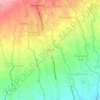
Name: Mabini topographic map, elevation, terrain.

Location: Mabini, Lipa, Batangas, Calabarzon, 4217, Philippines (13.87681 121.12916 13.91681 121.16916)

Average elevation: 823 ft

Minimum elevation: 633 ft

Maximum elevation: 1,030 ft

Other topographic maps

Click on a map to view its topography, its elevation and its terrain.

Lipa City Community Park

Philippines > Batangas > Lipa > Latag

Average elevation: 1,020 ft

Malepunyo Mountain Range

Philippines > Batangas > Lipa

Average elevation: 968 ft

Pangao

Philippines > Batangas > Lipa

Average elevation: 1,063 ft

Pinagkawitan

Philippines > Batangas > Lipa

Average elevation: 732 ft

Sabang

Philippines > Batangas > Lipa

Average elevation: 1,063 ft

Tambo

Philippines > Batangas > Lipa

Average elevation: 1,158 ft

6

Philippines > Batangas > Lipa

Average elevation: 1,027 ft

Lumbang

Philippines > Batangas > Lipa

Average elevation: 1,138 ft

Halang

Philippines > Batangas > Lipa > Halang

Average elevation: 561 ft

Pangao

Philippines > Batangas > Lipa

Average elevation: 1,063 ft

Sabang

Philippines > Batangas > Lipa

Average elevation: 1,063 ft

Gear up for your next adventure:

🌧️Backpack Rain Cover - Keep gear dry in wet weather
🎒Waterproof Dry Bags - Keep your electronics and maps dry inside your pack
🏕️Tent Footprint - Protect your tent base from wear
⛑️Personal Locator Beacon - Safety beacon for emergencies
🏫Relief Map Kits - Hands-on tools for teaching landforms and elevation

As an Amazon Associate, this site earns from qualifying purchases at no extra cost to you.