
Make a donation
Gear up for your next adventure:
As an Amazon Associate, this site earns from qualifying purchases at no extra cost to you.
Lyme Regis topographic map
Click on the map to display elevation.
Make a donation
Gear up for your next adventure:
As an Amazon Associate, this site earns from qualifying purchases at no extra cost to you.
Lyme Regis
Lyme Regis is a coastal town in West Dorset, 25 miles (40 km) west of Dorchester and 25 miles (40 km) east of Exeter. It lies in Lyme Bay, on the English Channel coast at the Dorset–Devon border. At the 2011 census, it had a population of 3,671. The town has grown around the mouth of the River Lim (or Lym) which drops from a plateau at an altitude of about 200 m (660 ft) before flowing around 5–6 km (3–4 mi) south and south-east to the sea. Its name is of British origin and probably cognate with the Welsh llif meaning flood or stream. Historically there were mills along its length. Its lower reaches coincide with sections of three recreational footpaths: the Wessex Ridgeway, Liberty Trail and East Devon Trail.
Make a donation
Gear up for your next adventure:
As an Amazon Associate, this site earns from qualifying purchases at no extra cost to you.
About this map
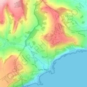
Name: Lyme Regis topographic map, elevation, terrain.
Location: Lyme Regis, Dorset, England, United Kingdom (50.71799 -2.95310 50.75428 -2.91578)
Average elevation: 272 ft
Minimum elevation: 0 ft
Maximum elevation: 673 ft
Make a donation
Gear up for your next adventure:
As an Amazon Associate, this site earns from qualifying purchases at no extra cost to you.
Other topographic maps
Click on a map to view its topography, its elevation and its terrain.