Geolocate

Patag topographic map

Click on the map to display elevation.

About this map

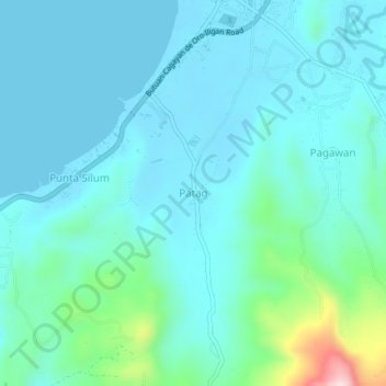
Name: Patag topographic map, elevation, terrain.

Location: Patag, Misamis Oriental, Northern Mindanao, 9024, Philippines (8.36046 124.26527 8.40046 124.30527)

Average elevation: 161 ft

Minimum elevation: 0 ft

Maximum elevation: 1,070 ft

Other topographic maps

Click on a map to view its topography, its elevation and its terrain.

Gingoog

Philippines > Misamis Oriental

Average elevation: 1,470 ft

Gear up for your next adventure:

🌡️Portable Weather Meter - Track weather conditions on the trail
🩹Survival Bandages - High‑quality bandages for emergencies
🎒Hydration Pack - Hands‑free water reservoir for long hikes
🚑Emergency Bivvies - Heat-reflective sleeping bags for survival situations
🩳Quick‑Dry Hiking Shorts - Comfortable and quick‑dry shorts for summer hiking

As an Amazon Associate, this site earns from qualifying purchases at no extra cost to you.