Geolocate

Youyu County topographic map

Click on the map to display elevation.

Youyu County

Elevations are generally higher in the south of the county, in which flows the Cangtou River (苍头河); Youyu reaches a north-south extent of 67.7 km (42.1 mi) and east-west width of 45.7 km (28.4 mi). The Great Wall demarcates the northwestern border with Inner Mongolia's Liangcheng and Horinger counties; within the province, Youyu borders Zuoyun County to the east, Shanyin County and Pinglu District to the south.

Wikipedia (CC-BY-SA 3.0)

About this map

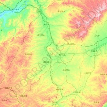
Name: Youyu County topographic map, elevation, terrain.

Location: Youyu County, Shuozhou City, Shanxi, China (39.69259 112.11211 40.29863 112.64180)

Average elevation: 4,875 ft

Minimum elevation: 3,707 ft

Maximum elevation: 6,752 ft

Other topographic maps

Click on a map to view its topography, its elevation and its terrain.

Xixian

China > Shanxi > Xi County > Xixian

Average elevation: 3,786 ft

Xiangyang

China > Shanxi > Xiangyang

Average elevation: 3,458 ft

Shiba

China > Shanxi > Ningwu County > Shiba

Average elevation: 5,246 ft

Hejin

China > Shanxi > Hejin City > Chengqu Subdistrict

Average elevation: 1,736 ft

Linyi

China > Shanxi > Linyi County

Average elevation: 1,493 ft

Gear up for your next adventure:

🗃️Trail First Aid Kit - Essential kit for outdoor injuries and emergencies
🛰️Handheld GPS Units - Professional satellite navigators for precise backcountry mapping
🔭Compact Binoculars - HD vision for scouting terrain and identifying distant landmarks
⛑️Personal Locator Beacon - Safety beacon for emergencies
🪶Thermal Camp Blanket - Extra warmth for cold nights

As an Amazon Associate, this site earns from qualifying purchases at no extra cost to you.