
Thank you for supporting this site ❤️
Make a donation
Make a donation
Gear up for your next adventure:
As an Amazon Associate, this site earns from qualifying purchases at no extra cost to you.
Pejerrey topographic map
Click on the map to display elevation.
Thank you for supporting this site ❤️
Make a donation
Make a donation
Gear up for your next adventure:
As an Amazon Associate, this site earns from qualifying purchases at no extra cost to you.
About this map
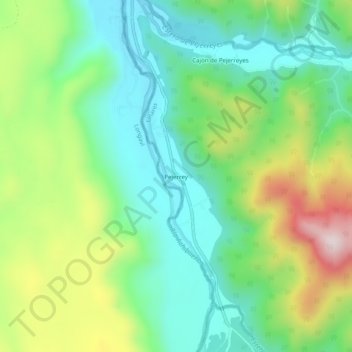
Name: Pejerrey topographic map, elevation, terrain.
Average elevation: 1,716 ft
Minimum elevation: 1,171 ft
Maximum elevation: 2,805 ft
Thank you for supporting this site ❤️
Make a donation
Make a donation
Gear up for your next adventure:
As an Amazon Associate, this site earns from qualifying purchases at no extra cost to you.
Other topographic maps
Click on a map to view its topography, its elevation and its terrain.
Santuario de la Naturaleza Cajón del Río Achibueno
Chile > Región del Maule > Provincia de Linares > Linares
Average elevation: 2,782 ft