
Make a donation
Gear up for your next adventure:
As an Amazon Associate, this site earns from qualifying purchases at no extra cost to you.
Cotterdale topographic map
Click on the map to display elevation.
Make a donation
Gear up for your next adventure:
As an Amazon Associate, this site earns from qualifying purchases at no extra cost to you.
About this map
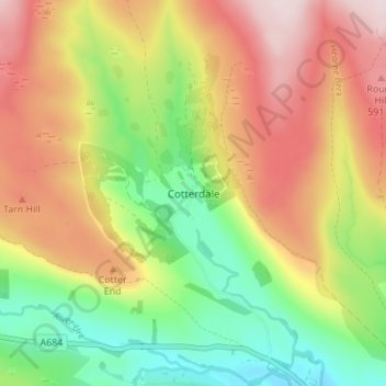
Name: Cotterdale topographic map, elevation, terrain.
Average elevation: 1,427 ft
Minimum elevation: 810 ft
Maximum elevation: 2,106 ft
Make a donation
Gear up for your next adventure:
As an Amazon Associate, this site earns from qualifying purchases at no extra cost to you.
Other topographic maps
Click on a map to view its topography, its elevation and its terrain.
Make a donation
Gear up for your next adventure:
As an Amazon Associate, this site earns from qualifying purchases at no extra cost to you.
Whitby
Verenigd Koninkrijk > Engeland > North Yorkshire
De plaats is bekend geworden door een aantal hoogtepunten in de geschiedenis en literatuur. Zo is de ontdekkingsreiziger James Cook verbonden met Whitby. Er staat dan ook een standbeeld van hem in de stad.
Average elevation: 121 ft