Geolocate

Tinompok topographic map

Click on the map to display elevation.

Tinompok

The park headquarters is 88 kilometres away from the city of Kota Kinabalu. There are sealed roads leading towards the park headquarters from other parts of Sabah. It is situated on the southern boundary of Kinabalu Park, at an elevation of 1,563 m (5,128 ft).

Wikipedia (CC-BY-SA 3.0)

About this map

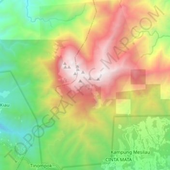
Name: Tinompok topographic map, elevation, terrain.

Location: Tinompok, Ranau, West Coast Division, Sabah, Malaysia, Kinabalu Park (6.00109 116.53037 6.12621 116.60500)

Average elevation: 6,768 ft

Minimum elevation: 2,208 ft

Maximum elevation: 13,327 ft

Other topographic maps

Click on a map to view its topography, its elevation and its terrain.

Kundasang

Malaysia > Sabah > Ranau

Average elevation: 4,196 ft

Gear up for your next adventure:

🥾Men's Hiking Boots - Durable, waterproof footwear for rugged terrain and steep inclines
🏔️Mountain Trail Maps - High‑detail maps for popular peaks
Camping Coffee Makers - Enjoy premium coffee at the summit or campsite
🪶Trail Camera - Capture wildlife on your hikes
🧭GPS Watch Accessories - Bands and chargers for GPS watches

As an Amazon Associate, this site earns from qualifying purchases at no extra cost to you.