
Inkhundla Maphalaleni topographic map
Interactive map
Click on the map to display elevation.
About this map
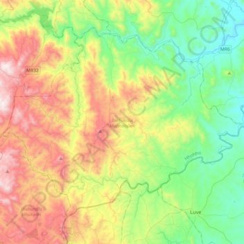
Name: Inkhundla Maphalaleni topographic map, elevation, terrain.
Location: Inkhundla Maphalaleni, Hhohho Region, Eswatini (-26.32773 31.18578 -26.07427 31.55007)
Average elevation: 2,425 ft
Minimum elevation: 1,010 ft
Maximum elevation: 4,921 ft
Other topographic maps
Click on a map to view its topography, its elevation and its terrain.
Mbabane
Eswatini > Hhohho Region > Inkhundla Mbabane
Mbabane, Inkhundla Mbabane, Hhohho Region, H100, Eswatini
Average elevation: 3,734 ft
Lobamba
Eswatini > Hhohho Region > Inkhundla Lobamba
Lobamba, Inkhundla Lobamba, Hhohho Region, Eswatini
Average elevation: 2,546 ft