
Thank you for supporting this site ❤️
Make a donation
Make a donation
Gear up for your next adventure:
As an Amazon Associate, this site earns from qualifying purchases at no extra cost to you.
Gemeinde Dürnstein topographic map
Click on the map to display elevation.
Thank you for supporting this site ❤️
Make a donation
Make a donation
Gear up for your next adventure:
As an Amazon Associate, this site earns from qualifying purchases at no extra cost to you.
About this map
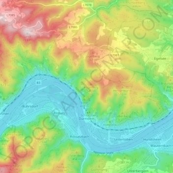
Name: Gemeinde Dürnstein topographic map, elevation, terrain.
Location: Gemeinde Dürnstein, Bezirk Krems, Lower Austria, 3601, Austria (48.38399 15.46369 48.43085 15.56227)
Average elevation: 1,253 ft
Minimum elevation: 614 ft
Maximum elevation: 2,316 ft
Thank you for supporting this site ❤️
Make a donation
Make a donation
Gear up for your next adventure:
As an Amazon Associate, this site earns from qualifying purchases at no extra cost to you.
Other topographic maps
Click on a map to view its topography, its elevation and its terrain.
Klein-Wien
Austria > Lower Austria > Bezirk Krems > Gemeinde Furth bei Göttweig
Average elevation: 1,010 ft