Geolocate

Burah topographic map

Click on the map to display elevation.

About this map

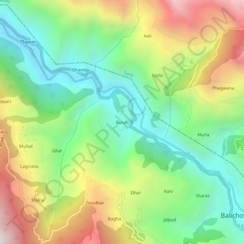
Name: Burah topographic map, elevation, terrain.

Location: Burah, Balichowki, Bali Chowki, Mandi, Himachal Pradesh, India (31.68447 77.23750 31.72447 77.27750)

Average elevation: 5,020 ft

Minimum elevation: 3,248 ft

Maximum elevation: 7,818 ft

Gear up for your next adventure:

🪶Camp Gear Gift Set - Perfect gift bundle for outdoor fans
🧯Emergency Survival Kit - All‑in‑one survival essentials for the backcountry
🧭Map Reading Tools - Tools and kits for map navigation
🗺️Topographic Maps - Detailed topo maps for hiking, exploring and outdoor navigation
🧭Compass with Lanyard - Easy‑carry compass for navigation

As an Amazon Associate, this site earns from qualifying purchases at no extra cost to you.