Geolocate

Shipman topographic map

Click on the map to display elevation.

About this map

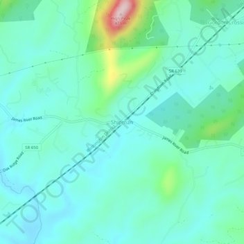
Name: Shipman topographic map, elevation, terrain.

Location: Shipman, Nelson County, Virginia, 22971, United States (37.70375 -78.85919 37.74375 -78.81919)

Average elevation: 722 ft

Minimum elevation: 531 ft

Maximum elevation: 1,529 ft

Nelson County trails, hiking, mountain biking, running and outdoor activities

Other topographic maps

Click on a map to view its topography, its elevation and its terrain.

Piney River

United States > Virginia > Nelson County

Average elevation: 873 ft

Tye River

United States > Virginia > Nelson County

Average elevation: 823 ft

Gear up for your next adventure:

🧭Compass with Lanyard - Easy‑carry compass for navigation
Solar GPS Watches - Advanced multisport watches with built-in topographic maps
📱Heavy-Duty Phone Cases - Drop-proof and waterproof protection for outdoor navigation
🩳Quick‑Dry Hiking Shorts - Comfortable and quick‑dry shorts for summer hiking
🪑Portable Camp Table - Compact table for campsite meals

As an Amazon Associate, this site earns from qualifying purchases at no extra cost to you.