
Make a donation
Gear up for your next adventure:
As an Amazon Associate, this site earns from qualifying purchases at no extra cost to you.
Probsthainer Spitzberg topographic map
Click on the map to display elevation.
Make a donation
Gear up for your next adventure:
As an Amazon Associate, this site earns from qualifying purchases at no extra cost to you.
Probsthainer Spitzberg
Der Probsthainer Spitzberg (polnisch Ostrzyca) mit einer Höhe von 501 m in den westlichen Ausläufern des Bober-Katzbach-Gebirges in Schlesien. Wegen seiner markanten konischen Form wird er deutsch auch als schlesischer Fuji bezeichnet.
Make a donation
Gear up for your next adventure:
As an Amazon Associate, this site earns from qualifying purchases at no extra cost to you.
About this map
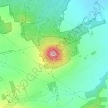
Name: Probsthainer Spitzberg topographic map, elevation, terrain.
Average elevation: 1,073 ft
Minimum elevation: 892 ft
Maximum elevation: 1,499 ft
Make a donation
Gear up for your next adventure:
As an Amazon Associate, this site earns from qualifying purchases at no extra cost to you.