
Make a donation
Gear up for your next adventure:
As an Amazon Associate, this site earns from qualifying purchases at no extra cost to you.
Veracruz City topographic map
Click on the map to display elevation.
Make a donation
Gear up for your next adventure:
As an Amazon Associate, this site earns from qualifying purchases at no extra cost to you.
Veracruz City
As the municipal seat, the city of Veracruz is the governing authority for 128 other named localities during the 2010 census, forming a municipality with a territory of 241 km2 (93 sq mi). The population of the municipality is 552,156 inhabitants, of whom 428,323 or approximately 77.6% live in municipality's portion of the city proper. The municipality is bordered by the municipalities of La Antigua, Boca del Río, Manlio Fabio Altamirano, Medellín, and Paso de Ovejas, with the Gulf of Mexico to the northeast, and has an average altitude of ten meters above sea level. The area is flat with little in the way of elevations and is crossed by the Medio, Grande and Tonayán Rivers. There are also beaches here such as the Sacrificios and Verde. Its climate is tropical with an average temperature of 25.3 °C (77.5 °F). Vegetation is mostly of the rainforest type, with many trees losing leaves during the winter dry season. Fauna mostly consists of birds, small mammals and insects.
Make a donation
Gear up for your next adventure:
As an Amazon Associate, this site earns from qualifying purchases at no extra cost to you.
About this map
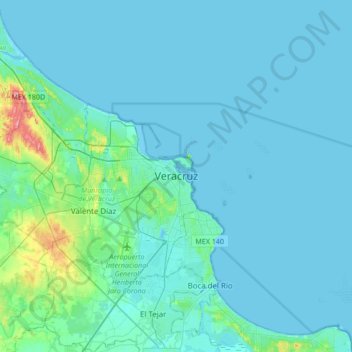
Name: Veracruz City topographic map, elevation, terrain.
Average elevation: 33 ft
Minimum elevation: -7 ft
Maximum elevation: 381 ft
Make a donation
Gear up for your next adventure:
As an Amazon Associate, this site earns from qualifying purchases at no extra cost to you.