Geolocate

Praiano topographic map

Click on the map to display elevation.

About this map

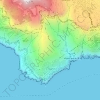
Name: Praiano topographic map, elevation, terrain.

Location: Praiano, Salerno, Campania, Italy (40.60680 14.51086 40.62564 14.53921)

Average elevation: 951 ft

Minimum elevation: 0 ft

Maximum elevation: 3,399 ft

Other topographic maps

Click on a map to view its topography, its elevation and its terrain.

Iaconti

Italy > Campania > Salerno > Vietri sul Mare

Average elevation: 935 ft

Montepertuso

Italy > Campania > Salerno > Arienzo

Average elevation: 1,493 ft

Marina di Vietri

Italy > Campania > Salerno > Vietri sul Mare

Average elevation: 463 ft

Pogerola

Italy > Campania > Salerno

Average elevation: 1,191 ft

Bosco

Italy > Campania > Salerno

Average elevation: 1,273 ft

Civitella

Italy > Campania > Salerno > Moio della Civitella

Average elevation: 2,014 ft

Monte Cervati

Italy > Campania > Salerno > Sanza

Average elevation: 5,322 ft

Catona

Italy > Campania > Salerno

Average elevation: 1,404 ft

Iaconti

Italy > Campania > Salerno > Vietri sul Mare

Average elevation: 935 ft

Erchie

Italy > Campania > Salerno > Maiori

Average elevation: 430 ft

Ariano

Italy > Campania > Salerno

Average elevation: 922 ft

San Severino

Italy > Campania > Salerno > Centola

Average elevation: 896 ft

Gear up for your next adventure:

📱Heavy-Duty Phone Cases - Drop-proof and waterproof protection for outdoor navigation
🧣Merino Neck Gaiters - Multi-functional headwear for wind and sun protection
🎒Hydration Pack - Hands‑free water reservoir for long hikes
🚗GPS Dash Cams - Record your scenic drives through mountain passes and canyons
🪑Ultralight Camp Chairs - Portable seating for resting after a long day of mapping

As an Amazon Associate, this site earns from qualifying purchases at no extra cost to you.