Geolocate

Korta topographic map

Click on the map to display elevation.

About this map

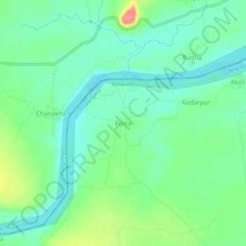
Name: Korta topographic map, elevation, terrain.

Location: Korta, Jainad Mandal, Adilabad, Telangana, India (19.79125 78.49887 19.83125 78.53887)

Average elevation: 735 ft

Minimum elevation: 659 ft

Maximum elevation: 909 ft

Gear up for your next adventure:

📚Navigation Handbooks - Master the art of reading topographic maps and using a compass
🪶Multi‑Purpose Knife - Useful blade for camp and trail
🛰️Satellite Messengers - Emergency SOS and two-way messaging for off-grid adventures
📷Action Cameras - Rugged cameras to document your journeys across rugged terrain
🎒Gear Packing Cubes - Organize your backpack efficiently

As an Amazon Associate, this site earns from qualifying purchases at no extra cost to you.