Geolocate

Madhuban topographic map

Click on the map to display elevation.

About this map

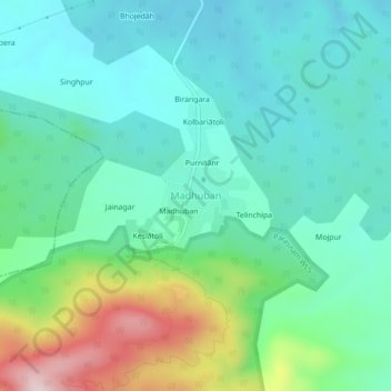
Name: Madhuban topographic map, elevation, terrain.

Location: Madhuban, Pirtanr, Giridih, Jharkhand, India (23.98608 86.12902 24.02608 86.16902)

Average elevation: 1,371 ft

Minimum elevation: 1,037 ft

Maximum elevation: 2,379 ft

Other topographic maps

Click on a map to view its topography, its elevation and its terrain.

Pirtanr

India > Jharkhand > Pirtanr

Average elevation: 1,089 ft

Gear up for your next adventure:

🔭Telescopic Hiking Pole - Adjustable pole for hiking stability
🏕️Family Camping Gear - Essentials for group camping trips
📖Nature Tracking Books - Learn to track wildlife and terrain
🏥Hiking First Aid Kits - Comprehensive medical kits for remote trail injuries
🧢Outdoor Hiking Hat - Sun protection hat for outdoor explorers

As an Amazon Associate, this site earns from qualifying purchases at no extra cost to you.