Geolocate

Tumiyang topographic map

Click on the map to display elevation.

About this map

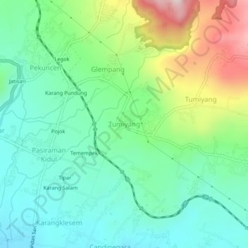
Name: Tumiyang topographic map, elevation, terrain.

Location: Tumiyang, Banyumas, Central Java, Java, 53164, Indonesia (-7.38306 109.07660 -7.34306 109.11660)

Average elevation: 1,063 ft

Minimum elevation: 604 ft

Maximum elevation: 2,119 ft

Other topographic maps

Click on a map to view its topography, its elevation and its terrain.

Kali Tajum

Indonesia > Central Java > Banyumas > Tipar Kidul

Average elevation: 325 ft

Kali Tajum

Indonesia > Central Java > Banyumas > Tipar Kidul

Average elevation: 305 ft

Logawa

Indonesia > Central Java > Banyumas > Karanganyar

Average elevation: 217 ft

Gear up for your next adventure:

🧭Orienteering Set - Complete compass and map reading kit
⛑️Personal Locator Beacon - Safety beacon for emergencies
🛶Inflatable Kayak - Portable kayak for rivers, lakes, and expeditions
📦Dry Bags Set - Waterproof storage for electronics and clothes
🚪Portable Camp Chair - Foldable chair for comfort at camp

As an Amazon Associate, this site earns from qualifying purchases at no extra cost to you.