Geolocate

Powers topographic map

Click on the map to display elevation.

About this map

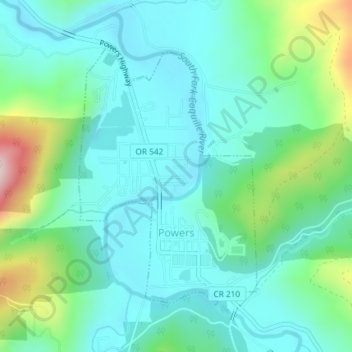
Name: Powers topographic map, elevation, terrain.

Location: Powers, Coos County, Oregon, 97466, United States (42.87646 -124.08148 42.89626 -124.06288)

Average elevation: 476 ft

Minimum elevation: 187 ft

Maximum elevation: 1,453 ft

Coos County trails, hiking, mountain biking, running and outdoor activities

Other topographic maps

Click on a map to view its topography, its elevation and its terrain.

Fairview

United States > Oregon > Coos County

Average elevation: 312 ft

Broadbent

United States > Oregon > Coos County

Average elevation: 223 ft

Tenmile

United States > Oregon > Coos County

Average elevation: 82 ft

Allegany

United States > Oregon > Coos County

Average elevation: 387 ft

Saunders Lake

United States > Oregon > Coos County

Average elevation: 115 ft

Glasgow

United States > Oregon > Coos County

Average elevation: 95 ft

Dora

United States > Oregon > Coos County

Average elevation: 594 ft

Bridge

United States > Oregon > Coos County

Average elevation: 466 ft

Laurel Grove

United States > Oregon > Coos County

Average elevation: 167 ft

Bay Park

United States > Oregon > Coos County > Bay Park

Average elevation: 89 ft

Gear up for your next adventure:

🥇GPS Hiking Watch - Multi‑sport GPS watch with navigation and trail tracking
🧥Waterproof Jacket for Hiking - Breathable and rugged rain jacket for outdoor excursions
🧭Outdoor Navigation Book - Learn advanced navigation skills
Camping Coffee Makers - Enjoy premium coffee at the summit or campsite
🧯Emergency Survival Kit - All‑in‑one survival essentials for the backcountry

As an Amazon Associate, this site earns from qualifying purchases at no extra cost to you.