
Waihola Hill topographic map
Interactive map
Click on the map to display elevation.
About this map
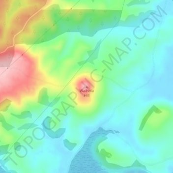
Name: Waihola Hill topographic map, elevation, terrain.
Location: Waihola Hill, Clutha District, Otago, 9243, New Zealand (-46.00530 170.05739 -46.00520 170.05749)
Average elevation: 180 ft
Minimum elevation: -10 ft
Maximum elevation: 620 ft
Other topographic maps
Click on a map to view its topography, its elevation and its terrain.
Lawrence
New Zealand > Otago > Clutha District
Lawrence, Clutha District, Otago, 9532, New Zealand
Average elevation: 535 ft
Waitahuna Hill
New Zealand > Otago > Clutha District
Waitahuna Hill, Clutha District, Otago, New Zealand
Average elevation: 1,762 ft
Beaumont
New Zealand > Otago > Clutha District
Beaumont, Clutha District, Otago, New Zealand
Average elevation: 400 ft
Balclutha
New Zealand > Otago > Clutha District
Balclutha, Clutha District, Otago, 9230, New Zealand
Average elevation: 131 ft
Owaka
New Zealand > Otago > Clutha District
Owaka, Clutha District, Otago, 9535, New Zealand
Average elevation: 89 ft
Clinton
New Zealand > Otago > Clutha District
Clinton, Clutha District, Otago, 9534, New Zealand
Average elevation: 502 ft
Tokoiti
New Zealand > Otago > Clutha District > Milton > Tokoiti
Tokoiti, Milton, Clutha District, Otago, 9220, New Zealand
Average elevation: 164 ft
Taieri Mouth
New Zealand > Otago > Clutha District
Taieri Mouth, Clutha District, Otago, New Zealand
Average elevation: 151 ft
Kapiti
New Zealand > Otago > Clutha District
Kapiti, Clutha District, Otago, 9291, New Zealand
Average elevation: 302 ft
Tapanui Hill
New Zealand > Otago > Clutha District
Tapanui Hill, Clutha District, Otago, New Zealand
Average elevation: 2,457 ft