
Thank you for supporting this site ❤️
Make a donation
Make a donation
Gear up for your next adventure:
As an Amazon Associate, this site earns from qualifying purchases at no extra cost to you.
Kebili topographic map
Click on the map to display elevation.
Thank you for supporting this site ❤️
Make a donation
Make a donation
Gear up for your next adventure:
As an Amazon Associate, this site earns from qualifying purchases at no extra cost to you.
About this map
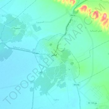
Name: Kebili topographic map, elevation, terrain.
Location: Kebili, جنعورة, معتمدية قبلي الشمالية, Kébili, 4200, Tunisia (33.66611 8.92984 33.74611 9.00984)
Average elevation: 141 ft
Minimum elevation: 66 ft
Maximum elevation: 614 ft
Thank you for supporting this site ❤️
Make a donation
Make a donation
Gear up for your next adventure:
As an Amazon Associate, this site earns from qualifying purchases at no extra cost to you.