
Make a donation
Gear up for your next adventure:
As an Amazon Associate, this site earns from qualifying purchases at no extra cost to you.
Pollux topographic map
Click on the map to display elevation.
Make a donation
Gear up for your next adventure:
As an Amazon Associate, this site earns from qualifying purchases at no extra cost to you.
Pollux
Pollux, ital. Punta Polluce, ist ein Gipfel in den Walliser Alpen im Kanton Wallis an der Grenze zur italienischen Provinz Aosta. Mit einer Höhe von 4089 m ü. M. ist er der niedrigere der beiden Zwillinge und liegt nordwestlich des Castors. Die Zwillinge Castor und Pollux liegen zwischen dem Breithorn-Massiv und dem Liskamm. Sie werden durch das Zwillingsjoch (ital. Passo di Verra, 3846 m ü. M.) getrennt.
Make a donation
Gear up for your next adventure:
As an Amazon Associate, this site earns from qualifying purchases at no extra cost to you.
About this map
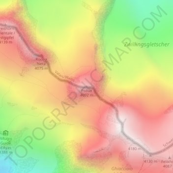
Name: Pollux topographic map, elevation, terrain.
Location: Pollux, Zermatt, Visp, Wallis, 3920, Schweiz (45.92776 7.78526 45.92786 7.78536)
Average elevation: 11,972 ft
Minimum elevation: 9,619 ft
Maximum elevation: 13,727 ft
Make a donation
Gear up for your next adventure:
As an Amazon Associate, this site earns from qualifying purchases at no extra cost to you.
Other topographic maps
Click on a map to view its topography, its elevation and its terrain.
Gornergletscher
Schweiz > Wallis > Visp > Zermatt
Unterhalb der ehemaligen Vereinigung des Gornergletschers mit dem zweiten Hauptarm, dem Grenzgletscher, reicht das Gletschersystem Gorner-/Grenzgletscher flankiert vom Breithorn im Süden und dem Gornergrat im Norden, noch rund 5 km weiter nach Westen, wobei hier die Neigung nur noch sehr flach ist. Das Eis…
Average elevation: 10,430 ft
Make a donation
Gear up for your next adventure:
As an Amazon Associate, this site earns from qualifying purchases at no extra cost to you.
Mattertal
Schweiz > Wallis > Visp > Zermatt
Der tiefste Punkt des Mattertals liegt auf 723,5 m ü. M. am unteren Ende des Tals bei Stalden. Mehrere Gipfel der Berge, die das Tal von drei Seiten umschliessen, erheben sich auf über 4500 m. Davon sind der Dom im Osten und das Weisshorn im Westen die einzigen, die nicht auf dem Alpenhauptkamm liegen. Der…
Average elevation: 7,772 ft