Geolocate

Baguio topographic map

Click on the map to display elevation.

About this map

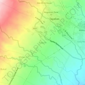
Name: Baguio topographic map, elevation, terrain.

Location: Baguio, Tayabas, Quezon, Calabarzon, 4327, Philippines (13.99517 121.56608 14.03517 121.60608)

Average elevation: 627 ft

Minimum elevation: 269 ft

Maximum elevation: 1,142 ft

Gear up for your next adventure:

🥩Freeze-Dried Meals - Nutritious and lightweight food for remote expeditions
📶Satellite Messenger - Communication device off‑grid
🔋Rechargeable Batteries - Power up your outdoor devices
🧭Map Reading Tools - Tools and kits for map navigation
🔭Telescopic Hiking Pole - Adjustable pole for hiking stability

As an Amazon Associate, this site earns from qualifying purchases at no extra cost to you.