Geolocate

Boxelder topographic map

Click on the map to display elevation.

About this map

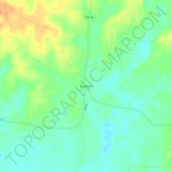
Name: Boxelder topographic map, elevation, terrain.

Location: Boxelder, Red River County, Texas, United States (33.45983 -94.90188 33.49983 -94.86188)

Average elevation: 361 ft

Minimum elevation: 312 ft

Maximum elevation: 443 ft

Red River County trails, hiking, mountain biking, running and outdoor activities

Other topographic maps

Click on a map to view its topography, its elevation and its terrain.

Detroit

United States > Texas > Red River County

Average elevation: 492 ft

Gear up for your next adventure:

🪶Camping Sleeping Pad - Comfortable sleeping pad for backpacking
🧯Portable Fire Pit - Compact fire pit for camping spots
🔪Outdoor Multitools - Essential survival tools for gear repair and field use
🌄Hiking Binoculars - Compact binoculars for scenic views and trail spotting
🥇GPS Hiking Watch - Multi‑sport GPS watch with navigation and trail tracking

As an Amazon Associate, this site earns from qualifying purchases at no extra cost to you.