
Make a donation
Gear up for your next adventure:
As an Amazon Associate, this site earns from qualifying purchases at no extra cost to you.
Taraira topographic map
Click on the map to display elevation.
Make a donation
Gear up for your next adventure:
As an Amazon Associate, this site earns from qualifying purchases at no extra cost to you.
Taraira
Taraira es un municipio colombiano ubicado en el departamento del Vaupés. Se encuentra sobre la frontera con Brasil, localizado a 170 km al sur de Mitú, la capital departamental. Se encuentra a una altitud de 100 m s. n. m., registrando temperaturas entre los 27 y 30 °C. Con 2215 habitantes.
Make a donation
Gear up for your next adventure:
As an Amazon Associate, this site earns from qualifying purchases at no extra cost to you.
About this map
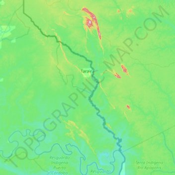
Name: Taraira topographic map, elevation, terrain.
Location: Taraira, Vaupés, RAP Amazonía, Colombia (-1.22767 -70.32747 -0.10835 -69.41799)
Average elevation: 420 ft
Minimum elevation: 184 ft
Maximum elevation: 2,093 ft
Make a donation
Gear up for your next adventure:
As an Amazon Associate, this site earns from qualifying purchases at no extra cost to you.
Other topographic maps
Click on a map to view its topography, its elevation and its terrain.
Make a donation
Gear up for your next adventure:
As an Amazon Associate, this site earns from qualifying purchases at no extra cost to you.
Make a donation
Gear up for your next adventure:
As an Amazon Associate, this site earns from qualifying purchases at no extra cost to you.