
Make a donation
Gear up for your next adventure:
As an Amazon Associate, this site earns from qualifying purchases at no extra cost to you.
Edith topographic map
Click on the map to display elevation.
Make a donation
Gear up for your next adventure:
As an Amazon Associate, this site earns from qualifying purchases at no extra cost to you.
About this map
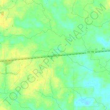
Name: Edith topographic map, elevation, terrain.
Location: Edith, Beauregard Parish, Louisiana, 70657, United States (30.49631 -93.17571 30.53631 -93.13571)
Average elevation: 59 ft
Minimum elevation: 23 ft
Maximum elevation: 92 ft
Beauregard Parish trails, hiking, mountain biking, running and outdoor activities
Make a donation
Gear up for your next adventure:
As an Amazon Associate, this site earns from qualifying purchases at no extra cost to you.
Other topographic maps
Click on a map to view its topography, its elevation and its terrain.
DeRidder
United States > Louisiana > Beauregard Parish
DeRidder is located in northern Beauregard Parish at 30°51′5″N 93°17′25″W / 30.85139°N 93.29028°W / 30.85139; -93.29028 (30.851419, -93.290230) and has an elevation of 203 feet (61.9 m). U.S. Route 171 leads south 48 miles (77 km) to Lake Charles and north 15 miles (24 km) to the entrance…
Average elevation: 190 ft