
Make a donation
Gear up for your next adventure:
As an Amazon Associate, this site earns from qualifying purchases at no extra cost to you.
Sarno topographic map
Click on the map to display elevation.
Make a donation
Gear up for your next adventure:
As an Amazon Associate, this site earns from qualifying purchases at no extra cost to you.
About this map
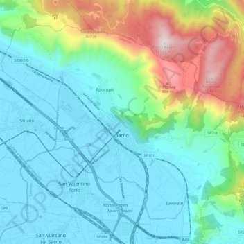
Name: Sarno topographic map, elevation, terrain.
Location: Sarno, Salerno, Campania, 84087, Italy (40.78185 14.56471 40.84875 14.67555)
Average elevation: 886 ft
Minimum elevation: 39 ft
Maximum elevation: 3,665 ft
Make a donation
Gear up for your next adventure:
As an Amazon Associate, this site earns from qualifying purchases at no extra cost to you.
Other topographic maps
Click on a map to view its topography, its elevation and its terrain.
Make a donation
Gear up for your next adventure:
As an Amazon Associate, this site earns from qualifying purchases at no extra cost to you.
Make a donation
Gear up for your next adventure:
As an Amazon Associate, this site earns from qualifying purchases at no extra cost to you.
Make a donation
Gear up for your next adventure:
As an Amazon Associate, this site earns from qualifying purchases at no extra cost to you.
Pontecagnano Faiano
Italy > Campania > Salerno > Pontecagnano Faiano > Pontecagnano Faiano
Average elevation: 259 ft