
Cleveland topographic map
Click on the map to display elevation.
Cleveland
Cleveland features a diverse topography shaped significantly by its proximity to Lake Erie and the Cuyahoga River. The city is characterized by a rapid elevation change, with the lakefront sitting at approximately 569 feet above sea level. Just inland, Public Square rises to about 650 feet, while further from the shore, Hopkins Airport reaches an elevation of around 791 feet. The area showcases a mixture of flat plains and gently rolling hills, particularly in the outer neighborhoods, which rise towards the higher elevations of the Glaciated Allegheny Plateau. The Cuyahoga River, flowing through the city, has carved a significant gorge, contributing to the region's varied landscape. Overall, Cleveland’s topography is marked by its scenic views of both the waterfront and the surrounding hilly terrain, providing a unique backdrop for the urban environment.
About this map
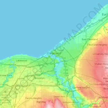
Name: Cleveland topographic map, elevation, terrain.
Location: Cleveland, Cuyahoga County, Ohio, United States (41.39063 -81.87909 41.60444 -81.53274)
Average elevation: 705 ft
Minimum elevation: 564 ft
Maximum elevation: 1,165 ft
Cuyahoga County trails, hiking, mountain biking, running and outdoor activities
Other topographic maps
Click on a map to view its topography, its elevation and its terrain.
Cuyahoga Valley National Park
United States > Ohio > Cuyahoga County > Independence
Average elevation: 686 ft
Cleveland
United States > Ohio > Cuyahoga County > Cleveland
The land rises quickly from the lake shore elevation of 569 feet. Public Square, less than one mile (1.6 km) inland, sits at an elevation of 650 feet (198 m), and Hopkins Airport, 5 miles (8 km) inland from the lake, is at an elevation of 791 feet (241 m).
Average elevation: 719 ft