Geolocate

Diamond Harbour topographic map

Click on the map to display elevation.

Diamond Harbour

Diamond Harbour is located at 22°11′28″N 88°11′26″E / 22.1910091°N 88.1904741°E / 22.1910091; 88.1904741. It has an average elevation of 8 metres (26 ft).

Wikipedia (CC-BY-SA 3.0)

About this map

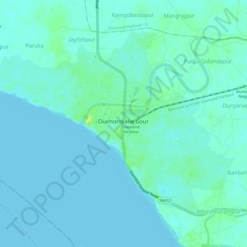
Name: Diamond Harbour topographic map, elevation, terrain.

Location: Diamond Harbour, Diamond Harbour - I, South 24 Parganas, West Bengal, 743331, India (22.17355 88.16038 22.21085 88.21394)

Average elevation: 10 ft

Minimum elevation: -3 ft

Maximum elevation: 52 ft

Gear up for your next adventure:

🧤Hiking Gloves - Protective gloves for rugged trails
🔥Plasma Lighters - Windproof lighters that work in any weather condition
👖Convertible Hiking Pants - Versatile zip-off pants for changing altitudes and temperatures
🔋Solar Power Banks - Keep your GPS and phone charged in remote wilderness areas
🪶Wildlife Field Guides - Learn animal tracking and species ID

As an Amazon Associate, this site earns from qualifying purchases at no extra cost to you.