
Royal topographic map
Click on the map to display elevation.
About this map
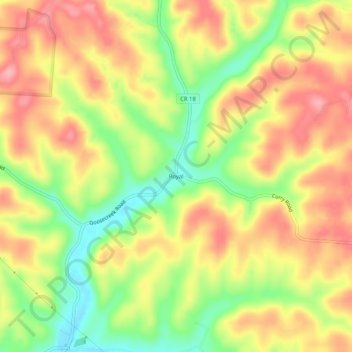
Name: Royal topographic map, elevation, terrain.
Location: Royal, Vinton County, Ohio, United States (39.28590 -82.59294 39.32590 -82.55294)
Average elevation: 896 ft
Minimum elevation: 686 ft
Maximum elevation: 1,063 ft
Vinton County trails, hiking, mountain biking, running and outdoor activities
Other topographic maps
Click on a map to view its topography, its elevation and its terrain.
Waterloo State Wildlife Management Area
United States > Ohio > Vinton County
Average elevation: 876 ft