Geolocate

Madison topographic map

Click on the map to display elevation.

About this map

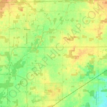
Name: Madison topographic map, elevation, terrain.

Location: Madison, Williams County, Ohio, United States (41.61692 -84.57290 41.70387 -84.47587)

Average elevation: 883 ft

Minimum elevation: 823 ft

Maximum elevation: 925 ft

Williams County trails, hiking, mountain biking, running and outdoor activities

Other topographic maps

Click on a map to view its topography, its elevation and its terrain.

Bridgewater Center

United States > Ohio > Williams County

Average elevation: 906 ft

Lake Seneca

United States > Ohio > Williams County

Average elevation: 922 ft

Jim Town

United States > Ohio > Williams County

Average elevation: 883 ft

Gear up for your next adventure:

🔥Camping Stove - Portable stove for camping and backcountry cooking
🦟Ultrasonic Repellers - Create a bug-free zone at your camp or rest stop
🔪Outdoor Multitools - Essential survival tools for gear repair and field use
📻Weather Alert Radios - Stay informed of storm risks while off-the-grid
📌Outdoor GPS Map App - Apps and devices for digital topographic navigation

As an Amazon Associate, this site earns from qualifying purchases at no extra cost to you.