Geolocate

Baunatal topographic map

Click on the map to display elevation.

About this map

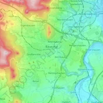
Name: Baunatal topographic map, elevation, terrain.

Location: Baunatal, Landkreis Kassel, Hesse, 34225, Germany (51.22023 9.32666 51.28034 9.48271)

Average elevation: 823 ft

Minimum elevation: 449 ft

Maximum elevation: 1,834 ft

Other topographic maps

Click on a map to view its topography, its elevation and its terrain.

Hirschköpfchen

Germany > Hesse > Landkreis Kassel

Average elevation: 968 ft

Trendelburg

Germany > Hesse > Landkreis Kassel

Average elevation: 653 ft

Gear up for your next adventure:

🔌USB Car Charger - Car charger for on‑the‑go power needs
🧦Hiking Socks - Comfortable socks to prevent blisters on long hikes
🔦LED Headlamp - Bright and durable LED headlamp for night navigation
🚪Portable Camp Chair - Foldable chair for comfort at camp
📖Nature Tracking Books - Learn to track wildlife and terrain

As an Amazon Associate, this site earns from qualifying purchases at no extra cost to you.