
Anini topographic map
Click on the map to display elevation.
Anini
The small settlement of Anini is located at an elevation of 1,968 metres (6,457 ft) above sea level. On the Aninese Plateau, the average elevation is 1,800 meters, but the average elevation of the town is 2,068 meters. According to Google Maps' terrain feature, Anini is around 1,600–1,800 meters above sea level and up north of Anini, the elevation can go up to 3,800 meters above sea level. According to the official website of the Dibang Valley District, Anini's altitude is at 1,968 meters above sea level.
About this map
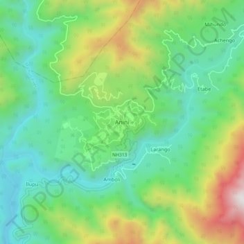
Name: Anini topographic map, elevation, terrain.
Location: Anini, Anini Circle, Dibang Valley, Arunachal Pradesh, India (28.75693 95.86448 28.83693 95.94448)
Average elevation: 5,446 ft
Minimum elevation: 3,540 ft
Maximum elevation: 9,938 ft