Geolocate

Daingerfield topographic map

Click on the map to display elevation.

About this map

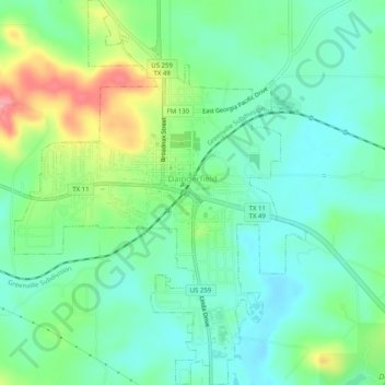
Name: Daingerfield topographic map, elevation, terrain.

Location: Daingerfield, Morris County, Texas, 75638, United States (33.00916 -94.74537 33.05140 -94.70710)

Average elevation: 390 ft

Minimum elevation: 285 ft

Maximum elevation: 623 ft

Morris County trails, hiking, mountain biking, running and outdoor activities

Other topographic maps

Click on a map to view its topography, its elevation and its terrain.

Cason

United States > Texas > Morris County

Average elevation: 318 ft

Gear up for your next adventure:

🧭Outdoor Navigation Book - Learn advanced navigation skills
📦Dry Bags Set - Waterproof storage for electronics and clothes
🚑Emergency Bivvies - Heat-reflective sleeping bags for survival situations
🥾Women's Hiking Boots - Top-rated trail boots with ankle support and superior grip
🗺️NatGeo Topo Maps - High-quality waterproof printed topographic maps of US Parks

As an Amazon Associate, this site earns from qualifying purchases at no extra cost to you.