
Make a donation
Gear up for your next adventure:
As an Amazon Associate, this site earns from qualifying purchases at no extra cost to you.
Robinson Crusoe Island topographic map
Click on the map to display elevation.
Make a donation
Gear up for your next adventure:
As an Amazon Associate, this site earns from qualifying purchases at no extra cost to you.
Robinson Crusoe Island
Robinson Crusoe has a subtropical climate, moderated by the cold Humboldt Current, which flows to the east of the island, and the southeast trade winds. Temperatures range from 3 °C (37 °F) to 34 °C (93 °F), with an annual mean of 15.4 °C (60 °F). Higher elevations are generally cooler, with occasional frosts. Rainfall is greater in the winter months, and varies with elevation and exposure; elevations above 500 m (1,640 ft) experience almost daily rainfall, while the western, leeward side of the island is lower and drier.
Make a donation
Gear up for your next adventure:
As an Amazon Associate, this site earns from qualifying purchases at no extra cost to you.
About this map
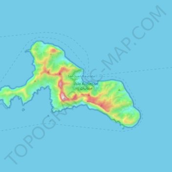
Name: Robinson Crusoe Island topographic map, elevation, terrain.
Average elevation: 144 ft
Minimum elevation: -3 ft
Maximum elevation: 2,933 ft
Make a donation
Gear up for your next adventure:
As an Amazon Associate, this site earns from qualifying purchases at no extra cost to you.