
Make a donation
Gear up for your next adventure:
As an Amazon Associate, this site earns from qualifying purchases at no extra cost to you.
Bethania topographic map
Click on the map to display elevation.
Make a donation
Gear up for your next adventure:
As an Amazon Associate, this site earns from qualifying purchases at no extra cost to you.
About this map
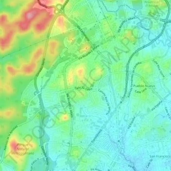
Name: Bethania topographic map, elevation, terrain.
Location: Bethania, Distrito de Panamá, Panamá Province, 0818, Panama (8.98863 -79.54182 9.03643 -79.50957)
Average elevation: 161 ft
Minimum elevation: 33 ft
Maximum elevation: 453 ft
Make a donation
Gear up for your next adventure:
As an Amazon Associate, this site earns from qualifying purchases at no extra cost to you.
Other topographic maps
Click on a map to view its topography, its elevation and its terrain.
Cerro Jefe
Panama > Panamá Province > Distrito de Panamá > 24 de Diciembre
Average elevation: 2,769 ft
Make a donation
Gear up for your next adventure:
As an Amazon Associate, this site earns from qualifying purchases at no extra cost to you.
Las Cumbres
Panama > Panamá Province > Distrito de Panamá > Las Cumbres > Las Lajas
Average elevation: 545 ft
Make a donation
Gear up for your next adventure:
As an Amazon Associate, this site earns from qualifying purchases at no extra cost to you.
Make a donation
Gear up for your next adventure:
As an Amazon Associate, this site earns from qualifying purchases at no extra cost to you.