Geolocate

Mentor topographic map

Click on the map to display elevation.

About this map

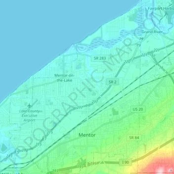
Name: Mentor topographic map, elevation, terrain.

Location: Mentor, Lake County, Ohio, 44060, United States (41.64021 -81.39095 41.75889 -81.29073)

Average elevation: 650 ft

Minimum elevation: 564 ft

Maximum elevation: 1,263 ft

Lake County trails, hiking, mountain biking, running and outdoor activities

Other topographic maps

Click on a map to view its topography, its elevation and its terrain.

Madison-on-the-Lake

United States > Ohio > Lake County

Average elevation: 591 ft

Mentor-on-the-Lake

United States > Ohio > Lake County > Mentor

Average elevation: 610 ft

Gear up for your next adventure:

📻Weather Alert Radios - Stay informed of storm risks while off-the-grid
🔭Stargazing Telescopes - Perfect for camping in low-light pollution areas shown on maps
🔥Fast-Boil Camping Stoves - Efficient cooking systems for quick trail meals
🎒Day Hiking Backpack - Lightweight backpack perfect for day trips and outdoor adventures
🚗GPS Dash Cams - Record your scenic drives through mountain passes and canyons

As an Amazon Associate, this site earns from qualifying purchases at no extra cost to you.