
Thank you for supporting this site ❤️
Make a donation
Make a donation
Gear up for your next adventure:
As an Amazon Associate, this site earns from qualifying purchases at no extra cost to you.
Caserio topographic map
Click on the map to display elevation.
Thank you for supporting this site ❤️
Make a donation
Make a donation
Gear up for your next adventure:
As an Amazon Associate, this site earns from qualifying purchases at no extra cost to you.
About this map
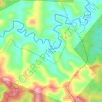
Name: Caserio topographic map, elevation, terrain.
Location: Caserio, Quibdó, Chocó, RAP Pacífico, Colombia (5.93184 -76.95860 5.97184 -76.91860)
Average elevation: 427 ft
Minimum elevation: 125 ft
Maximum elevation: 938 ft
Thank you for supporting this site ❤️
Make a donation
Make a donation
Gear up for your next adventure:
As an Amazon Associate, this site earns from qualifying purchases at no extra cost to you.