Geolocate

Malabuan topographic map

Click on the map to display elevation.

About this map

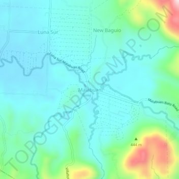
Name: Malabuan topographic map, elevation, terrain.

Location: Malabuan, North Cotabato, Soccsksargen, Philippines (6.86599 125.03623 6.90599 125.07623)

Average elevation: 617 ft

Minimum elevation: 364 ft

Maximum elevation: 1,637 ft

Gear up for your next adventure:

🥾Hiking Shoes - Durable and comfortable shoes for trail hiking
📻Weather Alert Radios - Stay informed of storm risks while off-the-grid
🔦Compact Flashlight - Reliable flashlight for emergencies
🔊Portable Camp Speaker - Music and alerts at camp
📱Heavy-Duty Phone Cases - Drop-proof and waterproof protection for outdoor navigation

As an Amazon Associate, this site earns from qualifying purchases at no extra cost to you.